


GARMIN GPSMAP 1223XSV 12" DISPLAY
Couldn't load pickup availability
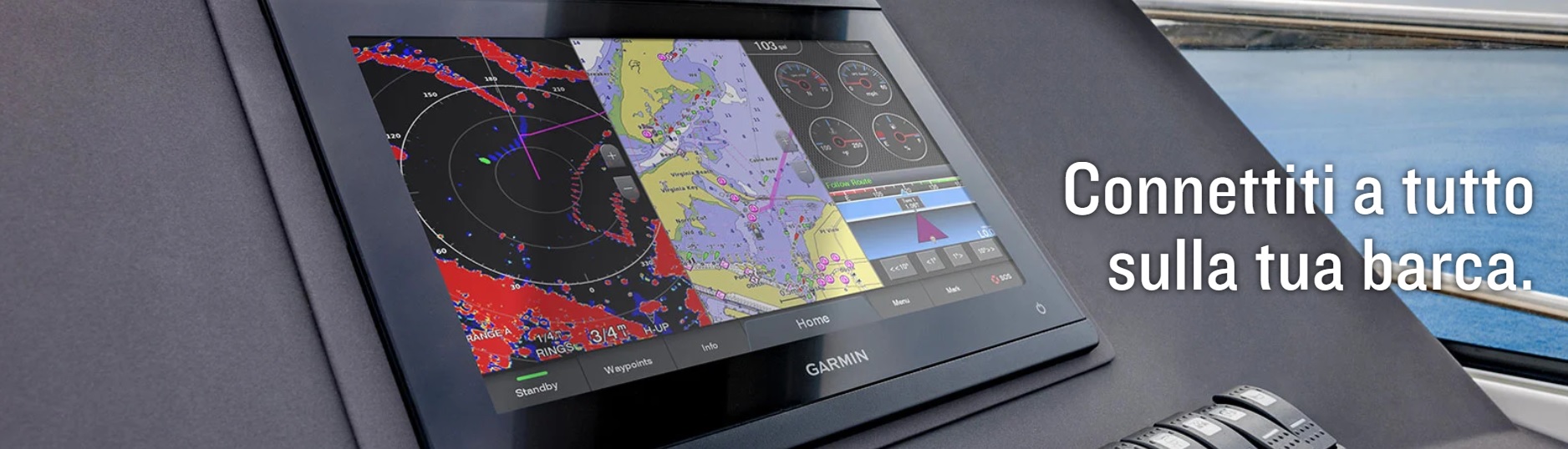
TOTAL INTEGRATION DURING NAVIGATION
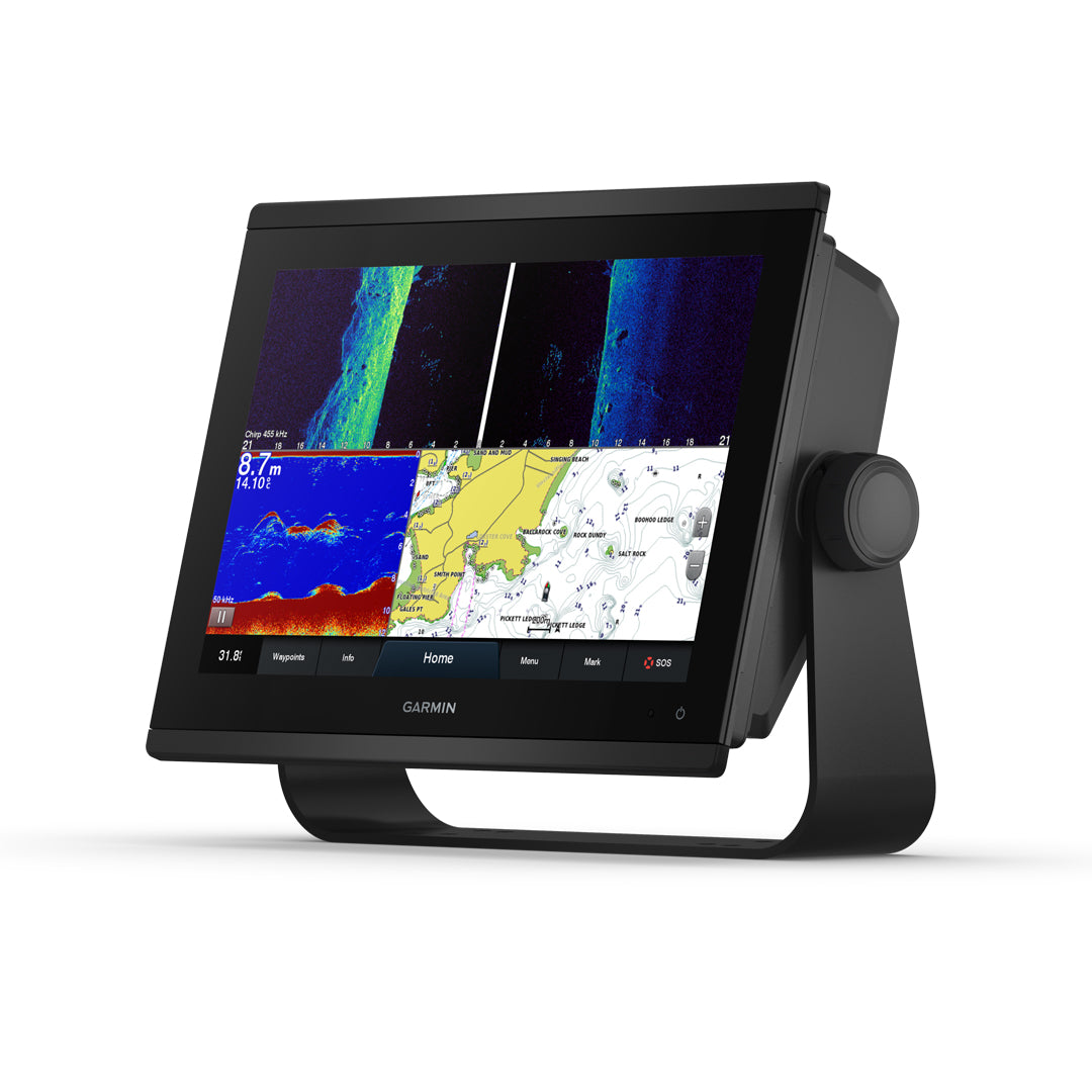
With 60% more display pixels and nearly double the processing power of previous-generation 12-inch GPSMAP devices, this crisp, high-resolution chartplotter integrates seamlessly into your Garmin marine system.
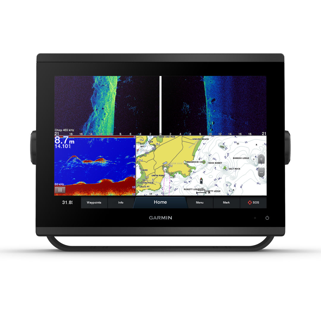
![]() See beneath your boat with built-in sonar capabilities.
See beneath your boat with built-in sonar capabilities.
![]() Easily integrates with multiple engines.
Easily integrates with multiple engines. ![]() Connect to third-party devices compatible with OneHelm™ digital switching.
Connect to third-party devices compatible with OneHelm™ digital switching.
![]() Easily build your own marine system using the best in network connectivity.
Easily build your own marine system using the best in network connectivity.
![]() Compatible with premium maps and charts 1 for the best in Garmin navigation.
Compatible with premium maps and charts 1 for the best in Garmin navigation.
![]() Manage sailing with clear laylines and more, right on your screen.
Manage sailing with clear laylines and more, right on your screen.
![]() Manage your boating experience from anywhere. 2
Manage your boating experience from anywhere. 2
HIGH DEFINITION SCANNING FISHFINDER
Get built-in ultra-high-definition SideVü and ClearVü scanning sonar with vivid, high-contrast color palettes to distinguish fish from structure. GPSMAP® 1223xsv also supports traditional 1kW CHIRP sonar.
FASTER, MORE EYE-CATCHING, SMARTER
With its added processing power and new slim, all-glass design and smaller unit footprint, this 12-inch plotter is easy to upgrade to a wider range of dashboard configurations.
IMPROVED DISPLAY OPTICS
The new, higher-resolution 12-inch displays offer improved sunlight readability with 60% more pixels than previous-generation 12-inch GPSMAP devices.
GARMIN SAILASSIST™ SAILING FEATURES
View laylines, race start line guide, improved wind rose, heading and course lines, true wind data fields and tide/current/time slider, wind angle, setting and drift, wind speed and more.
OPTIONAL BLUECHART ® G3 VISION ® TREES
These optional maps offer the best of Garmin and Navionics® data, Auto Guidance 4 technology and other premium navigation features.
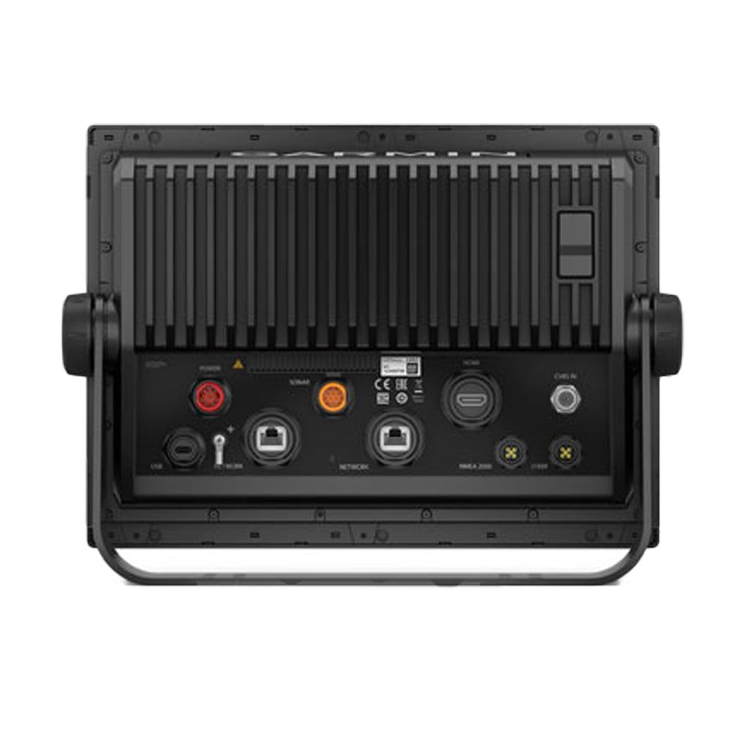
GARMIN MARINE NETWORK
If you have multiple compatible Garmin devices on your boat, you can share information between them, such as maps, user data, radar and IP camera video.
NMEA 2000® AND NMEA 0183 NETWORKS
Connect to compatible autopilots, digital switching, weather, Fusion-Link™ audio system, media, VHF, AIS and more from a single screen.
ACTIVECAPTAIN® APP
Built-in Wi-Fi® connectivity pairs with the free all-in-one mobile app for access to the OneChart™ feature, smart notifications, software updates, Garmin Helm™ digital switching, Garmin Quickdraw™ community data and more. 5
INTEGRATED ANT® TECHNOLOGY
Connect with some of your favorite devices, like quatix® marine watches, gWind™ Wireless 2 transducers, GNX™ Wind marine instruments and wireless remotes.
J1939 CONNECTIVITY
Now you can connect your chartplotter to a variety of engine types, including select Yamaha engines.
ONEHELM™ FEATURE
This unique feature brings together all the operations and capabilities of select third-party devices, such as EmpirBus™ digital switching, on a single screen.
Package Contents:
GPSMAP 1223xsv Chartplotter
Power cord
Bracket mounting kit with knobs
Flush mounting kit with gasket
Protective cover
Snap-on dashboard trim protectors
Documentation
General
DIMENSIONS 12.1" x 8.9" x 3.2" (30.8 x 22.8 x 8.2 cm)
SCREEN SIZE, LXH
10.3" x 6.4"; 12.1" diagonal
(26.2 x 16.3 cm; 30.7 cm diagonal)
SCREEN RESOLUTION, LXA 1280 x 800 pixels
SCREEN TYPE WXGA display
WEIGHT 6.6 lbs. (3.0 kg)
IPX7 WATERPROOF RATING
POLARIZED SUPPORT
ENERGY CONSUMPTION
Max power usage at 10 Vdc: 26.5 W
Typical current draw at 12 Vdc: 1.7 A
Max current draw at 12 Vdc: 2.2 A
GPS ANTENNA Internal or external on NMEA 2000 network
MOUNTING OPTIONS Bail or flush
RECEIVER 10 Hz high sensitivity
GARMIN MARINE NETWORK™ 2 PORTS
TRANSMISSION POWER 1 kW traditional; 1 kW CHIRP
Maps and Memory
EXTERNAL MEMORY 2 microSD™ cards (back of unit)
WAYPOINTS 5,000
TRACK LOG 50,000 points; 50 saved tracks
100 MEMORIZABLE PATHS
Functions for outdoor activities
TIDE DATA
Chartplotter Functions
COMPATIBLE WITH GARMIN RADAR
COMPATIBLE WITH GARMIN BLACK-BOXES Yes (built-in)
GARMIN SMARTMODE COMPATIBLE (CUSTOMIZABLE MONITOR PRESETS)
COMPATIBLE WITH AIS FUNCTION
COMPATIBLE WITH DSC FUNCTION
SUPPORTS FUSION-LINK™ COMPATIBLE RADIOS
BLACK BOX GSD™ FISHFINDER MOUNT
BLACK BOX GCV™ FISHFINDER MOUNT
ACTIVECAPTAIN COMPATIBLE
GRID™ (GARMIN REMOTE INPUT DEVICE) COMPATIBLE
WIRELESS CONNECTIVITY
SAILING FUNCTIONS
Fishfinder Features and Specifications
DUAL FREQUENCY
DOUBLE CONE
FREQUENCIES SUPPORTED Traditional: 50/77/83/200 kHz
CHIRP (low, medium, high)
ClearVü/SideVü (260/455/800 kHz)
(transducer dependent)
CHIRP Yes (built-in)
CLEARVÜ Yes with CHIRP (built-in)
SIDEVÜ Yes with CHIRP (built-in)
MAXIMUM DEPTH 5,000 ft at 1kW (depth capacity is dependent on water bottom type and other water conditions)
ZOOM
WATER TEMPERATURE DATA AND GRAPH
REGISTRATION
HISTORICAL
Connections
NMEA 2000® COMPATIBLE
TRANSDUCER PIN NUMBER 12-pin (orange)
NMEA 0183 INPUT PORTS 1
NMEA 0183 OUTPUT PORTS 1
VIDEO INPUT PORTS 1 BNC
VIDEO OUTPUT 1 HDMI
WIRELESS CONNECTIVITY
J1939 COMPATIBLE
Le spedizioni per l'Italia avvengono in 2-6 giorni lavorativi. Il costo è di €9,99 per i pagamenti effettuati con carta e di €14,99 per pagamenti con contrassegno.
Le spedizioni per i paesi UE avvengono in 4-9 giorni lavorativi. Il costo è di €30. Non è possibile effettuare il pagamento con contrassegno.
Le spedizioni per i paesi Extra UE avvengono in 6-10 giorni lavorativi. Il costo è di €50. Non è possibile effettuare il pagamento con contrassegno.