


GARMIN GPSMAP 8410XSV DISPLAY 10"
Couldn't load pickup availability
GPSMAP 8410 Chartplotter with 10" touchscreen and Full HD IPS (In-plane Switching) screen
Premium 10" Full HD widescreen multitouch display
Possibility of built-in or flush installation, for a wonderful super-technological crystal console
Built-in Wi-Fi® and ANT™ connectivity, 4 Ethernet ports, NMEA 2000® port, HDMI and USB port for total integration
Advanced Garmin SailAssist™ features for sailing
With SmartMode™ you can simultaneously change all the screens of the GPSMAP displays interfaced with each other to docking, cruising, fishing, anchoring and much more.
A wonderfully powerful instrument, integrated in 360°, enclosed in an ultra-sharp 10" full HD touch screen: among on-board instruments, a display like this has never been seen. GPSMAP® 8410 is equipped with a high-performance processor to process the cartography with unheard of speed and allows you to customize screens, data and indicators. Everything is designed to allow the user to quickly access, with a single gesture, all the information needed in the most stressful situations, such as docking.
GPSMAP 8410XSV 10" touchscreen chartplotter/sounder combo with full HD In-plane Switching (IPS) display
Premium 10" Full HD widescreen multitouch display
Integrated 1kW dual channel CHIRP sonar module
Possibility of built-in or flush installation, for a wonderful super-technological crystal console
Built-in Wi-Fi® and ANT™ connectivity, 4 Ethernet ports, NMEA 2000® port, HDMI and USB port for total integration
Advanced Garmin SailAssist™ features for sailing
With SmartMode™ you can simultaneously change all the screens of the GPSMAP displays interfaced with each other to docking, cruising, fishing, anchoring and much more.
A wonderfully powerful instrument, integrated 360°, enclosed in an ultra-sharp 10" full HD touch screen: among on-board instruments, a display like this has never been seen. GPSMAP® 8410xsv is equipped with a high-performance processor to process cartography with unprecedented speed and allows you to customize screens, data and indicators. Everything is designed to allow the user to quickly access, with a single gesture, all the information needed in the most stressful situations, such as docking.
GPSMAP® 8410xsv integrates the most advanced sonar capabilities available on the market, thanks to the integrated dual-channel CHIRP module with ClearVü-SideVü functions.
The complete CHIRP sonar 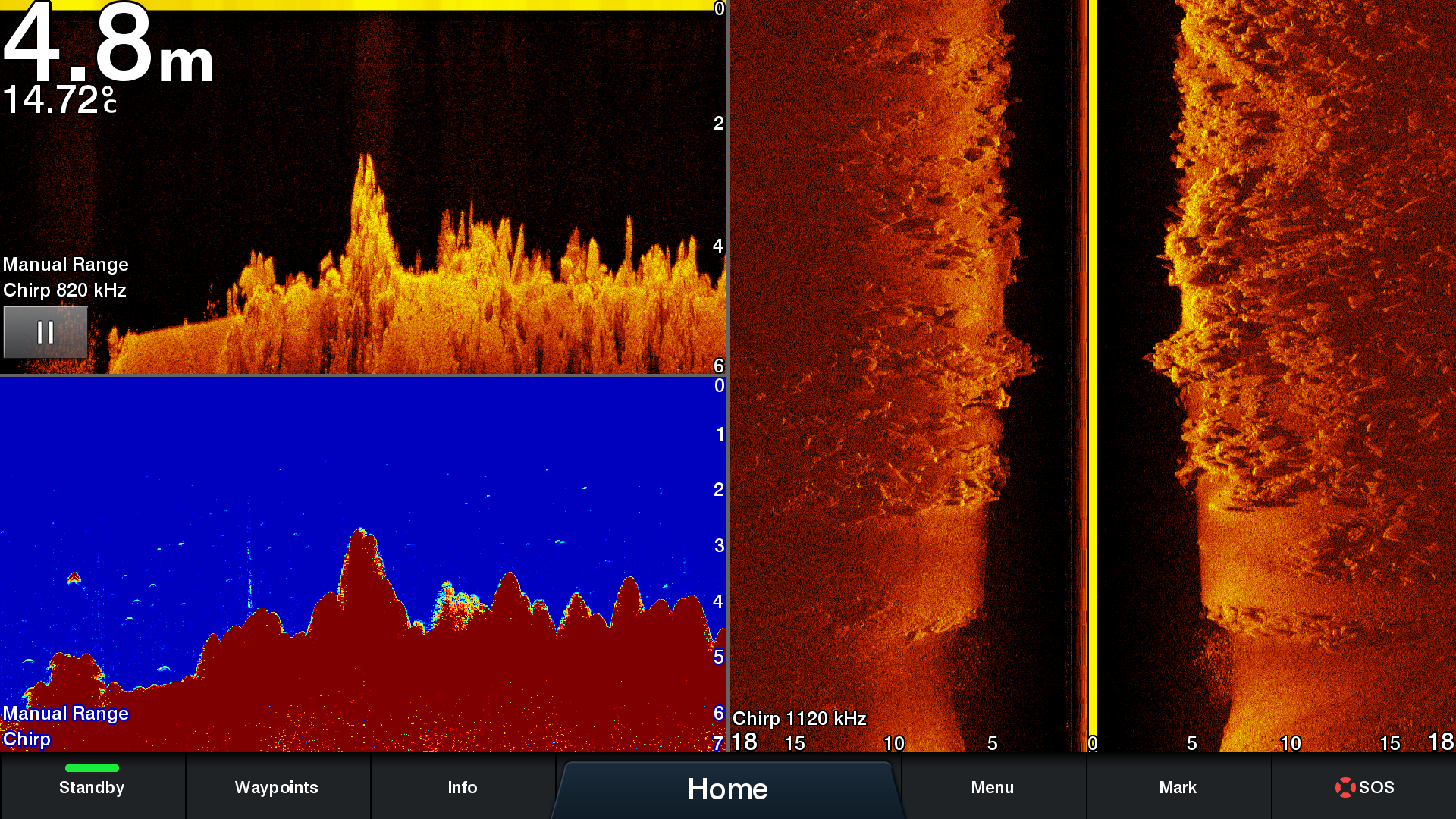
GPSMAP® 8410xsv features three different sonar technologies: CHIRP, ClearVü CHIRP and SideVü CHIRP. These three sonar modes work together to provide the best possible sonar identification of everything below and to the sides of your boat. It also supports the entire family of Panoptix™ sonars (transducers sold separately).
Create your own integrated system
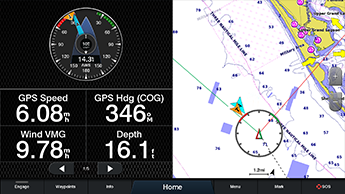
By connecting the GPSMAP® 8410 to the Garmin Marine Network, you can view data from onboard instruments such as radar, autopilots, sonar modules, multimedia devices (FUSION-Link), thermal imaging, GRID and much more on your display. GPSMAP® 8410 also allows you to share information with other compatible GPSMAP units, such as maps and user data, including waypoints, routes and tracks. This means that the user data entered can be automatically synchronized with other chartplotters on the network.
Connectivity without limits
The new GPSMAP® 8410 chartplotter integrates seamlessly with a variety of onboard instruments with built-in Wi-Fi® and ANT+ connectivity, 4 Ethernet ports, NMEA 2000 networking, HDMI port, USB port and more. It is also compatible with FLIR video cameras. Built-in Wi-Fi technology lets you use the free ActiveCaptain® app for access to OneChart™, smart notifications1, Garmin Quickdraw™ community data and more. You can also control streaming video playback from the GC™ 100 wireless video camera and VIRB® action cameras. Plus, built-in ANT wireless technology lets you directly connect to the quatix® watch, gWind™ Wireless 2 transducer and wireless remotes.
Digital Switching
Completely new interface for managing MasterBus and Czone on-board networks. You can start the engines, activate the pumps, turn on the underwater lights and monitor the warning lights directly from the chartplotter screen, all thanks to an intuitive and easy-to-use graphic.
The best of Garmin and the best of Navionics®
The new GPSMAP® 8410 display is compatible with the latest Garmin BlueChart® g3 and BlueChart® g3 Vision cartography , which integrates BlueChart data with Navionics data to offer the best cartography ever. This new cartography also includes Auto Guidance technology, which helps you avoid hazards and obstacles, planning safe routes to destinations you set based on the characteristics of your vessel 2.
Take control while sitting comfortably 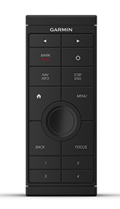
No more standing at the helm for hours. The optional, intuitive GRID™ 20 remote control provides remote access and ultimate control over your entire onboard Garmin system. It features a 360-degree joystick, rotary dial and push-to-select button for easy navigation and precise control of chartplotter menus and settings, even in rough seas.
 Regatta functions
The new GPSMAP® 8410 chartplotter has a useful feature dedicated to those who sail or compete in regattas. Thanks to SailAssist™ you can see on the screen the right moment to tack or gybe, view the apparent and true wind angle at the same time, keep an eye on tides and currents, view the heading and the course line at the same time, activate the pre-race guidance function to cross the starting line at the right time and with maximum speed and keep an eye on the wind thanks to the intuitive graphs.
Make your boat smart
Use the new ActiveCaptain™ application to connect your Garmin Marine chartplotter to the mobile network and make your boat smart. ActiveCaptain™ is free and will allow you to make the most of your on-board instruments.
General
Dimensions 25.9 cm x 20.5 cm x 7.5 cm
Screen size, WxH 21.8 cm x 13.7 cm
Screen resolution, WxH WUXGA; 1920 x 1200 px
Display Type IPS touchscreen display (anti-glare finish)
Weight 2.4 kg
IPX7 waterproof rating
Polarized Support
J1939 Compatible
Power consumption 2.7A
Internal or external GPS antenna on NMEA 2000 network
Mounting Options Mount, flush, or surface mount (Garmin does not offer flush mount hardware or accessories; professional tools and skills required.)
10 Hz GPS/GLONASS/Galileo receiver
Garmin Marine Network™ 2 ports
Maps and Memory
External Memory2 SD™ cards (on the back of the unit)
Waypoints 5,000
Storable routes 100 (250 waypoints each)
Track log 50,000 points; 50 saved tracks
Outdoor Activities Functions Tide Data
Chartplotter Functions
Compatible with Garmin radars
Compatible with Garmin black boxes yes
Garmin SmartMode compatible (customizable monitor presets)
Compatible with AIS function
Compatible with DSC function
FusionLync
Compatible with GSD™ black-box
Compatible with GCV™ black-box
BlueChart® Mobile yes
Garmin Helm™ yes
GRID™ (Garmin Remote Input Device)
Wireless Connectivity
Sailing Features
Fishfinder Features and Specifications
Dual frequency
Double cone
Frequencies supported
Traditional: 50/200, 77/200, 83/200
Single channel CHIRP: 40-250
Dual channel CHIRP: 40-250
SideVü/ClearVü: CHIRP 260/455/800
ClearVü UHD: 0.8 MHz (800 kHz), CHIRP Range: 760-880 kHz
SideVü UHD: 1.2 MHz (1200 kHz), CHIRP range: 1060-1170 kHz (transducer dependent)
Transmission power 1 kW traditional; 1 kW CHIRP
CHIRP Yes (built-in)
ClearVü yes
SideVü yes
Maximum depth 1,500 meters at 1kW (depth depends on seabed type and water conditions)
Connections
NMEA 2000®
Transducer Pin Number 1 x 12-PIN Sonar, 1 x 8-PIN Sonar, 1 x LVS Sonar
NMEA 0183 input 1 differential
NMEA 0183 output 1 differential
Video input
1 - BNC composite
1 - HDMI (HDCP compliant)
Video output 1 HDMI
Wireless Connectivity yes
Additional Features
Supports spoken audio alerts
Le spedizioni per l'Italia avvengono in 2-6 giorni lavorativi. Il costo è di €9,99 per i pagamenti effettuati con carta e di €14,99 per pagamenti con contrassegno.
Le spedizioni per i paesi UE avvengono in 4-9 giorni lavorativi. Il costo è di €30. Non è possibile effettuare il pagamento con contrassegno.
Le spedizioni per i paesi Extra UE avvengono in 6-10 giorni lavorativi. Il costo è di €50. Non è possibile effettuare il pagamento con contrassegno.