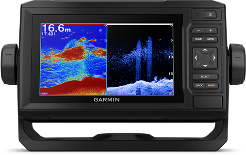
GARMIN ECHOMAP UHD 62CV WITHOUT TRANSDUCER
Couldn't load pickup availability
The new ECHOMAP™ UHD series combo chartplotter, available with a bright 6” color display, features Ultra High-Definition, Traditional CHIRP, CHIRP ClearVü™ sonar technology.
ENTER THE GARMIN WORLD
The new ECHOMAP™ UHD series combo chartplotter, available with a bright 6” color display, features Ultra High-Definition, Traditional CHIRP, CHIRP ClearVü™ sonar technology.
See what's beneath your boat in incredible detail with an optional transducer
Compatible with BlueChart® g3 & g3 Vision® HD and AutoGuidance features, NOT compatible with new Garmin Navionics charts
Manage your browsing experience wherever you are
Create your own maps anywhere and customize them to suit your needs
OPTIONAL TRANSDUCERS BUNDLE
Select the transducer bundle to add a GT24 transducer to Ultra High-Definition ClearVü scanning sonars that provide a clear view of what’s beneath your boat. You can also use traditional wide-range CHIRP sonar for superior obstacle separation. 
CARTOGRAPHIES AND MAPS
The new ECHOMAP™ UHD series combo chartplotters feature built-in Wi-Fi® connectivity that allows access to ActiveCaptain™, a new world of content that lets you: view, purchase, update and synchronize BlueChart® g3 and g3® g3 Vision cartography with integrated Navionics® content.
QUICKDRAW CONTOURS
Create custom fishing maps on your screen with 1' contours. Keep the data to yourself or share it with the QuickDraw™ community on Garmin Connect™.
Packaging
echoMAP UHD 62CV
Data/Power Cable
Quick release mount
Flush Mount Kit
Brackets for installation on the stern or on an electric motor
NMEA 2000 Cable
Quick Guide
General
DIMENSIONS 21.8 x 13.0 x 6.2 cm
SCREEN DIMENSIONS, WXH 13.7 x 7.7 cm; 15.2 cm (6.2") diagonal
SCREEN RESOLUTION, LXA 480 x 800 pixels
SCREEN TYPE WVGA display
WEIGHT 0.7 kg
IPX7 WATERPROOF RATING
POWER CONSUMPTION 12 W
GPS ANTENNA Internal or external on NMEA 2000 network
MOUNTING OPTIONS On bracket or flush mounted
RECEIVER 5Hz
GARMIN MARINE NETWORK™ PORTS None
Maps and Memory
PRELOADED CARTOGRAPHY World base map
EXTERNAL MEMORY 1 microSD™ card; with maximum capacity 32 GB
WAYPOINTS 5000
100 MEMORIZABLE PATHS
TRACK LOG 50,000 points; 50 saved tracks
Functions for outdoor activities
TIDE DATA
Chartplotter Functions
COMPATIBLE WITH GARMIN BLACK-BOXES
COMPATIBLE WITH AIS FUNCTION
COMPATIBLE WITH DSC FUNCTION
ACTIVECAPTAIN COMPATIBLE Yes
SAILING FUNCTIONS
Fishfinder Features and Specifications
DUAL FREQUENCY
DOUBLE CONE
TRANSMITTING POWER 500 W (RMS) / 4,000 W (peak-to-peak)
CHIRP Yes (built-in)
CLEARVÜ Yes with CHIRP (built-in)
SIDEWAYS No
MAX DEPTH 700 meters @ 77 kHz, fresh water 335 meters @ 77 kHz, salt water
(depth detection depends on factors such as bottom type and other water conditions)
ZOOM
WATER TEMPERATURE DATA AND GRAPH
REGISTRATION
HISTORICAL
Connections
NMEA 2000® COMPATIBLE
TRANSDUCER PIN NUMBER 4
NMEA 0183 INPUT PORTS 1
NMEA 0183 OUTPUT PORTS 1
VIDEO INPUT PORTS None
VIDEO OUTPUT None
WIRELESS CONNECTIVITY Yes
Le spedizioni per l'Italia avvengono in 2-6 giorni lavorativi. Il costo è di €9,99 per i pagamenti effettuati con carta e di €14,99 per pagamenti con contrassegno.
Le spedizioni per i paesi UE avvengono in 4-9 giorni lavorativi. Il costo è di €30. Non è possibile effettuare il pagamento con contrassegno.
Le spedizioni per i paesi Extra UE avvengono in 6-10 giorni lavorativi. Il costo è di €50. Non è possibile effettuare il pagamento con contrassegno.


